At the southern trailhead of the Old Croton Aqueduct State Historic Park, just below the New Croton Dam in Croton Gorge Park, the trail begins with a gentle climb. The path follows the line of an old maintenance road — a strip of ground perhaps fifteen feet wide, flanked by mature hardwood forest on both sides. Beneath the surface, invisible to anyone walking above, runs an elliptical brick-and-stone tunnel. The tunnel is 8.5 feet high and 7.5 feet wide. It drops 13 inches per mile from the Croton Dam south to what is now Central Park — an engineering grade so subtle that it would be imperceptible to a walker if the tunnel were above ground.
This is the Old Croton Aqueduct. For 113 years, from its opening on June 22, 1842, until it was finally decommissioned in 1955, the aqueduct carried clean water by gravity from the Croton River to the city of New York. When it opened, it ended the waterborne epidemics that had killed tens of thousands of New Yorkers. It made modern firefighting possible. It enabled the city's population to grow from half a million to nearly six million. It was, without exaggeration, the engineering achievement that made modern New York possible.
And now, above its route, runs a walking trail that is 26.2 miles long.
The Decision to Build
By the 1830s, Manhattan's water supply had become a public health catastrophe. The island's natural springs had been paved over; the Collect Pond had been filled in after becoming a sewage cesspool; the water from remaining wells was poisoning the people who drank it. Cholera epidemics in 1832 and 1834 killed thousands. The Great Fire of 1835 — which destroyed 17 blocks of lower Manhattan because the city's cisterns were too empty to fight it — demonstrated that the water problem was now beyond improvisation.
The New York City Council authorized construction of a new water supply system in 1835. The Water Commissioners looked north, to the Croton River, 41 miles away in Westchester County. The Croton drained a clean rural watershed and sat at an elevation high enough that water could flow to Manhattan entirely by gravity — no pumps, no steam engines, no moving parts. All that was required was the largest civil engineering project ever attempted in the Western Hemisphere.
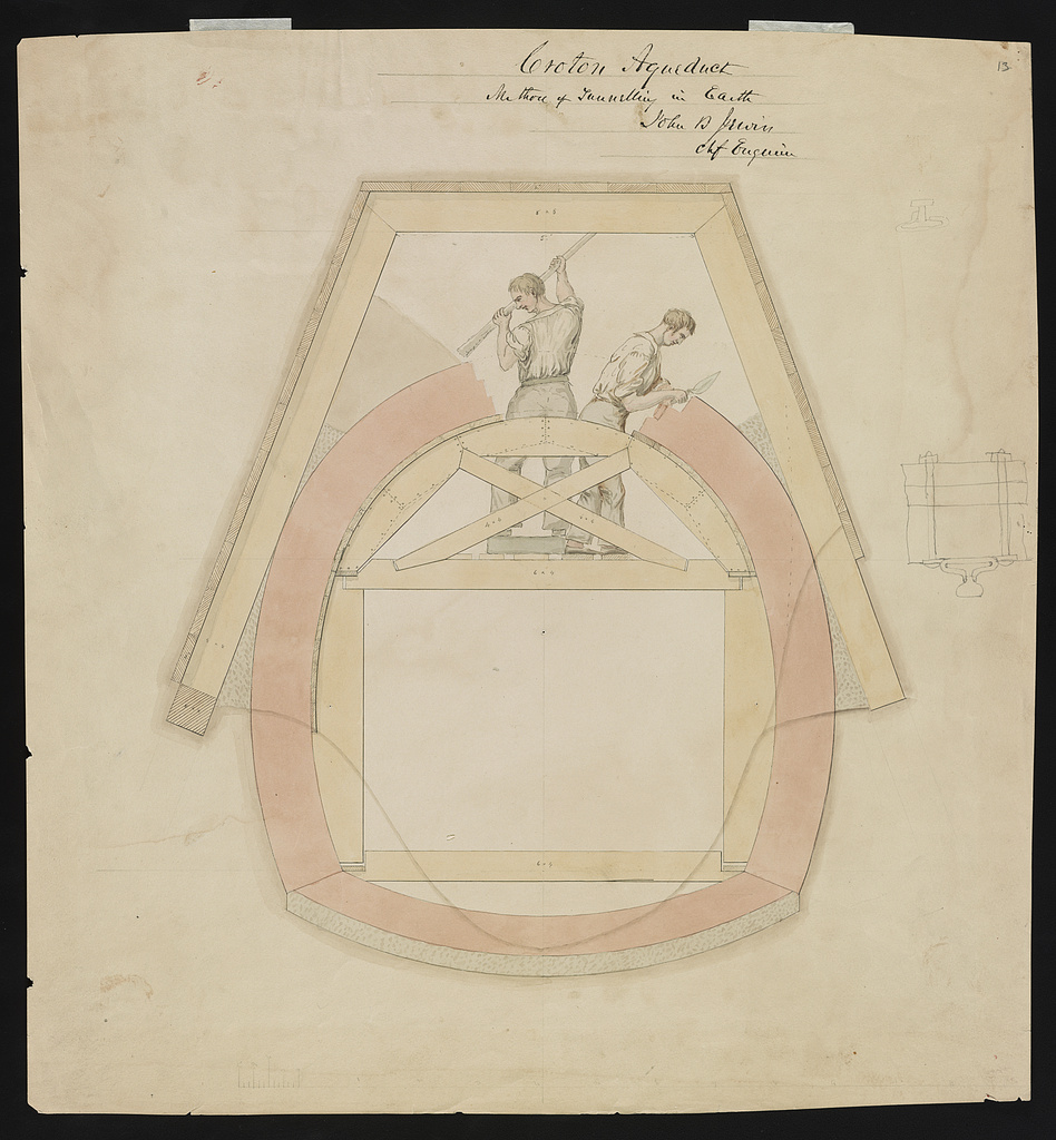
Chief engineer John B. Jervis designed the system. Construction began in 1837. Jervis's plan built on years of earlier proposals from other engineers and public figures — Christopher Colles had outlined a Croton water plan as far back as 1774, Aaron Burr's Manhattan Company had dug its own (disastrously inadequate) water system in 1799, Stephen Allen served as Water Commissioner during the planning years, and Major David Bates Douglass drew up the original survey for the aqueduct in 1833-34 before Jervis took over the chief engineer role. All four are credited alongside Jervis in the federal HAER historical documentation.
The aqueduct was built by thousands of Irish immigrants — many of them newly arrived, desperate for work, paid starvation wages. They hand-dug the tunnel, laid the stone walls, and built the High Bridge that carried the water across the Harlem River. The labor conditions were brutal; worker deaths were not systematically recorded but are believed to have numbered in the hundreds.
On June 22, 1842, water from the Croton River flowed into the receiving reservoir at Yorkville (now Central Park's Great Lawn) for the first time. On October 14, 1842, New York City celebrated with the largest parade in its history — a seven-mile procession through Manhattan, a 50-foot fountain erupting in City Hall Park, and the New York Sacred Music Society singing the Croton Ode adapted from Rossini. The whole celebration is documented in Story 11 of this archive.
The Aqueduct in Operation
For the next four decades, the Old Croton Aqueduct was the backbone of New York's water supply. Water flowed continuously from the original Croton Dam (not the New Croton Dam, which was not built until 1906) through the 41-mile masonry tunnel to the distributing reservoir on Murray Hill at 42nd Street and Fifth Avenue — the Egyptian Revival fortress where the main branch of the New York Public Library now stands.
Along the route, 33 conical stone ventilation towers rose above the ground at approximately one-mile intervals. Every third tower had a maintenance door — a heavy metal door built into the base, allowing inspectors to descend into the aqueduct itself and walk its length for cleaning and repair. The ventilation towers served a practical engineering purpose: they allowed air to circulate in the tunnel, preventing pressure buildups and keeping the water oxygenated during its long slow journey from Croton to Manhattan.
Twenty-one of the original 33 ventilation towers are still standing today. They are among the most distinctive features of the Old Croton Aqueduct Trail — squat stone cones, weathered but intact, rising from the forest at regular intervals along the line.
The aqueduct's most famous structure is High Bridge over the Harlem River. The 1,450-foot span, built between 1837 and 1848, carried the Croton water across the river on a line of Roman-style stone arches, modeled deliberately on classical aqueducts. The arches were a statement: American engineering was producing monuments equal to those of ancient Rome. High Bridge is still standing today — the oldest surviving bridge in New York City — and has been restored for pedestrian use.
The New Aqueduct and the Slow Retirement
By the 1880s, the Old Croton Aqueduct was no longer sufficient for New York's water needs. The city had grown faster than anyone in 1842 had imagined. Construction of the New Croton Aqueduct — a much larger tunnel with a daily capacity of 300 million gallons — began in 1885 and was completed in 1890. The new aqueduct took over primary service to the city.
But the old aqueduct was not shut down. For the next 65 years, it continued to carry water as a backup and supplementary supply, running alongside its larger successor. It was finally decommissioned in 1955, after 113 years of continuous service. It was the oldest piece of working water infrastructure in New York City when it was shut off.
For the next thirteen years, the old aqueduct right-of-way belonged to New York City but served no operational purpose. It was a 41-mile strip of land with a buried brick tunnel under it, crossing private and public property alike, managed by the Department of Water Supply essentially as an afterthought. Local walkers in Westchester and the Bronx had long used the aqueduct's maintenance path as an informal hiking trail, but there was no official recreational designation.
1968: A State Historic Park
In 1968, New York State purchased 26.2 miles of the aqueduct right-of-way from New York City — the section running from the Croton Dam south through Ossining, Scarborough, Sleepy Hollow, Tarrytown, Irvington, Dobbs Ferry, Hastings, Yonkers, and into the Bronx at Van Cortlandt Park. The state designated the land as the Old Croton Aqueduct State Historic Park, administered by the Taconic Region of the New York State Office of Parks, Recreation and Historic Preservation.
The purchase was a remarkable decision. Linear parks — parks that follow a narrow corridor rather than occupying a block of land — were rare in 1968. The idea of buying a strip of right-of-way that was mostly one path wide, in order to preserve both the historic engineering and the recreational value, was still novel. New York State's acquisition of the Old Croton Aqueduct corridor anticipated by decades the rails-to-trails movement that would transform abandoned rail lines across America into bike paths.
On December 2, 1974, the Old Croton Aqueduct was listed on the National Register of Historic Places (NRIS reference #74001324). On April 27, 1992, it was designated a National Historic Landmark — the highest level of federal historic recognition, reserved for sites of exceptional national significance. The aqueduct was also designated a Historic Civil Engineering Landmark by the American Society of Civil Engineers, placing it among the most important engineering achievements in American history.
In 1976-77, the federal Historic American Engineering Record (HAER) filed a comprehensive documentation of the aqueduct as HAER NY-120. Historian Larry D. Lankton wrote the 185-page technical narrative; photographer Jack Boucher — HAER's legendary in-house photographer, who shot most of the major American infrastructure in the large-format survey — took 53 black-and-white negatives of the aqueduct structures. The HAER record also includes a measured drawing and the field notes. It is held at the Library of Congress and is freely downloadable. Separate HAER records cover the Harlem River Crossing / High Bridge (NY-1175), the Sing Sing Kill Bridge (NY-1178), the Quarry Railroad Bridge at Hastings (NY-1174), and the Overseer's House at Dobbs Ferry (NY-1170). Together the five records form the most detailed engineering portrait of the aqueduct ever assembled.
The Trail Today
The Old Croton Aqueduct State Historic Park trail runs 26.2 miles from Croton Gorge Park south to the Yonkers/Bronx border at Van Cortlandt Park. (The remaining 15 miles of the original aqueduct, from the Bronx through Manhattan to the Distributing Reservoir, have been mostly built over and are no longer accessible as a continuous trail.)
Along its 26.2 miles, the trail passes through:
- Croton Gorge Park (trailhead, Cortlandt) — at the base of the New Croton Dam - Ossining — home to the Ossining Weir Chamber, an inspection vault where water could be diverted and the aqueduct's flow measured; also the massive Sing Sing Kill stone arch bridge, where the aqueduct crosses the gorge of Sing Sing Kill on a dramatic masonry span - Scarborough and Sleepy Hollow — residential suburbs where the trail winds past 19th-century estates and quiet woods - Tarrytown — where the aqueduct passes near the Rockefeller family estate at Kykuit - Irvington, Dobbs Ferry, Hastings-on-Hudson — three of the historic "river villages" along the trail - Yonkers — the most urban section, where the trail becomes a linear greenway running through neighborhoods and parks - Van Cortlandt Park in the Bronx — the southern terminus
The trail is used for walking, running, cycling (outside mud season), horseback riding in some sections, cross-country skiing in winter, and serious bird watching. It is maintained partly by NY State Parks staff and partly by the Friends of the Old Croton Aqueduct — a volunteer organization founded in 1981 that stewards interpretation, historical research, and restoration projects along the route.
What You Walk On
When you hike the Old Croton Aqueduct Trail, you are walking on top of a water supply system designed by a 19th-century engineer who never used a computer, never ran a simulation, and had to solve every problem with pencil, paper, and stone. The tunnel beneath your feet was dug by hand by immigrant workers who arrived in America with nothing and died building the infrastructure of the city that had been their destination. The bricks and stones were cut and laid with an accuracy that has held for more than 180 years.
The trail passes old farm walls, abandoned stone foundations, the weathered bases of the ventilation towers, and occasional signage from the Friends of the Old Croton Aqueduct explaining what you are looking at. Most visitors don't stop to read the signs. They walk, jog, or ride past. But the signs are there.
You can, in theory, walk the full 26.2 miles in a single day if you are in shape and start early. Most people do it in segments — a few miles at a time, over weeks or months, ticking off sections of the trail as they explore the Lower Hudson Valley. The aqueduct is one of the few places in southeastern New York where you can walk for miles through mostly unbroken corridor of protected land, emerging occasionally to cross a road or pass through a village, then ducking back into the woods that have grown up over the tunnel.
And at the end of it all, at the southern end of the trail in Van Cortlandt Park, the ground levels out and the corridor opens into the wider park. The aqueduct itself continues south — invisible, disused, partly filled in with modern urban debris — but the trail ends. You have walked, at a gentle downhill grade that perfectly matches the 13-inches-per-mile drop of the water that once flowed beneath you, from the base of one of the largest masonry dams in the world to the edge of New York City.
That is what the Old Croton Aqueduct State Historic Park is for. It is a place to walk in the footsteps of the engineers, the immigrant laborers, and the water that made New York possible.
Primary Sources (freely online): - Tower, Fayette B. Illustrations of the Croton Aqueduct. New York: Wiley & Putnam, 1843. 152 pages, 22 plates. The definitive contemporary illustrated record, drawn by an engineer who worked on the project. Internet Archive: https://archive.org/details/illustrationsofc00towe — alternate Wisconsin copy: https://archive.org/details/illustrationscr00leegoog — Project Gutenberg HTML: https://www.gutenberg.org/files/66640/66640-h/66640-h.htm — NYPL Digital Collections plate set: https://digitalcollections.nypl.org/collections/a7174220-c607-012f-025e-58d385a7bc34 — Metropolitan Museum of Art holding: https://www.metmuseum.org/art/collection/search/358076 . Named plates include Pl. XIII "Croton Aqueduct at Sing Sing" (p. 101) and Pl. XVI "At Jewell's Brook" (p. 104). - King, Charles. A Memoir of the Construction, Cost, and Capacity of the Croton Aqueduct. New York, 1843. 332 pages. The official account of the aqueduct including the Oct 14, 1842 civic celebration. Internet Archive: https://archive.org/details/memoirofconstruc00kingrich — NLM Digital Collections: https://collections.nlm.nih.gov/catalog/nlm:nlmuid-63150810R-bk - Schramke, Theophilus. Description of the New-York Croton Aqueduct. New York, 1843. A third contemporary primary source, published bilingually in German and English, cited in HAER Photo 25. - HAER NY-120, Old Croton Aqueduct (main record). 53 photographs, 1 measured drawing, 185 data pages, field notes FN-28. Historian: Larry D. Lankton. Photographer: Jack Boucher, 1976-77. Library of Congress: https://www.loc.gov/item/ny1181/ — photo gallery: https://www.loc.gov/resource/hhh.ny1181.photos?st=gallery — drawings: https://www.loc.gov/resource/hhh.ny1181.sheet - HAER NY-1175, Harlem River Crossing / High Bridge: https://www.loc.gov/item/ny1175/ - HAER NY-1178, Sing Sing Kill Bridge: https://www.loc.gov/pictures/item/ny1178/ - HAER NY-1174, Quarry Railroad Bridge (Hastings): https://www.loc.gov/item/ny1174/ - HAER NY-1170, Overseer's House (Dobbs Ferry): https://www.loc.gov/resource/hhh.ny1170.sheet/ - John B. Jervis Papers — Jervis Public Library, Rome NY. Boxes 1-18 cover Croton Aqueduct correspondence, specifications, contracts, cost estimates, monthly reports, and Harlem River Bridge details from 1831-1874. Finding aid and index: https://clrc.org/digital/jervis/jervispapers.htm — drawings index: https://clrc.org/digital/jervis/jervisdrwing.htm — New York Heritage hosted drawings: https://nyheritage.org/collections/john-b-jervis-drawings - NYPL Digital Collections — Croton Aqueduct materials: - 1842 celebration lithograph (J. F. Atwill, 201 Broadway): https://digitalcollections.nypl.org/items/5e66b3e8-f5b0-d471-e040-e00a180654d7 - "The Croton Aqueduct" print: https://digitalcollections.nypl.org/items/510d47e1-06fa-a3d9-e040-e00a18064a99 - Profile of lower aqueduct (1843): https://digitalcollections.nypl.org/items/4cec6cb0-c5aa-012f-99e1-58d385a7bc34 - High Bridge view: https://digitalcollections.nypl.org/items/107b8690-c557-012f-d994-58d385a7bc34 - Croton Reservoir at 42nd Street: https://digitalcollections.nypl.org/items/510d47e1-06fb-a3d9-e040-e00a18064a99 - Smithsonian NMAH — Croton Water Celebration object record: https://americanhistory.si.edu/collections/object/nmah_325910 - Fulton History (free NY newspaper archive) — contemporary 1842 coverage. Search NY Herald, Tribune, Evening Post Oct 14-22, 1842. The Dollar Weekly of Oct 22, 1842 ran a 16-inch front-page engraving of the procession. https://www.fultonhistory.com/Fulton.html
Secondary Sources: - New York State Parks. "Old Croton Aqueduct State Historic Park." parks.ny.gov/visit/state-parks/old-croton-aqueduct-state-historic-park - Wikipedia. "Croton Aqueduct" — construction dates, dimensions, High Bridge history - Friends of the Old Croton Aqueduct. aqueduct.org — interpretive/trail history (FOCA also records the 1857 construction date of the Keeper's House along the trail, and the 1987 reopening of the northernmost section after restoration) - Going Coastal. "Discover the Old Croton Aqueduct Trail." - Westchester Magazine. "The Old Croton Aqueduct Is a Picturesque Walking Trail." - NY State Parks. Old Croton Aqueduct Trail Map PDF. - National Historic Landmark designation. April 27, 1992. - National Register of Historic Places listing. December 2, 1974 (NRIS #74001324). - American Society of Civil Engineers. Historic Civil Engineering Landmark designation.